Maxar Captures ISS in Stunning Detail from Space
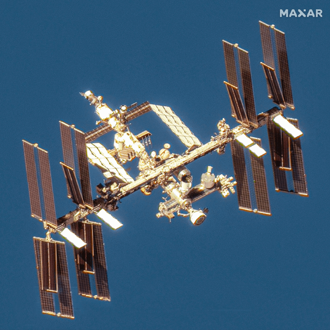
Credit: Maxar, 2024
In a landmark achievement for space technology, Maxar Technologies has captured stunning satellite images of Boeing’s Starliner spacecraft during its first astronaut mission, as it docked with the International Space Station (ISS). These images, taken on June 7, are a testament to the capabilities of non-Earth imaging (NEI), a technique that Maxar has pioneered to enhance space domain awareness for both government and commercial entities.
Pictures of space, from space
The NEI technology allows for high-resolution imaging of objects in space, which is critical for mission analysis and strategic operations. The images provided by Maxar offer a clear view of the Starliner as it approached and successfully docked with the ISS, marking a significant moment in space exploration.
This capability represents a major step forward in monitoring and documenting space missions. Traditionally focused on Earth observation, Maxar’s adaptation of its satellite technology to capture detailed activities beyond our planet is crucial for the future of space travel and security. These images are vital for assessing the spacecraft’s position and condition in real time, providing essential data that can influence decision-making processes during missions.
Space Domain Awareness capabilities
Maxar Intelligence is the first company authorized to perform non-Earth imaging (NEI) for both government and commercial uses. Its satellites provide detailed imagery of space objects in low Earth orbit (LEO), medium Earth orbit, and geosynchronous orbit.
The constellation can image LEO objects with resolutions finer than 6 inches and track a broader range of space. These capabilities enhance space resilience and situational awareness for various operators.
Maxar’s NEI addresses key areas such as:
- Space Domain Awareness: Identifying space objects and supporting mission planning.
- Space Traffic Management: Assisting with collision risk assessments and maneuver planning.
- Satellite Operations: Aiding in navigation safety and asset monitoring.
- National Security Missions: Supporting U.S. and allied security efforts.
As commercial and governmental activities in space continue to expand, the role of NEI in ensuring a safe and sustainable space environment becomes increasingly important. Maxar’s ability to deliver detailed and actionable imagery from space further solidifies its role as a key player in the ongoing space intelligence. Space domain awareness capabilities fulfill a growing need for commercial and military customers.
The success of this mission and the capabilities demonstrated by Maxar’s satellite imagery are expected to drive further innovations in space technology, making space more accessible and safer for future explorations.